

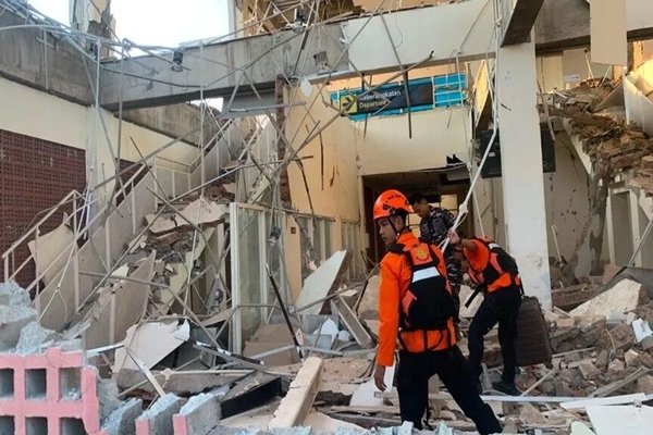
MAUMERE, EAST NUSA TENGGARA, INDONESIA | August 16, 2026
Death Toll Climbs as Rescue Operations Continue
The death toll from a powerful 7.7-magnitude earthquake that struck off the coast of Indonesia’s Flores Island has risen to 47, according to Indonesia’s National Disaster Management Agency (BNPB), as rescue teams continue searching damaged areas for survivors.
The earthquake struck eastern Indonesia on Saturday and caused widespread damage across parts of East Nusa Tenggara province. Several strong aftershocks followed, complicating rescue and recovery efforts.
Flores Region Among Worst Hit
The earthquake was centered off the northern coast of Flores Island, near Ende, and occurred at relatively shallow depth, increasing the impact across nearby communities.
Areas including Nagekeo, Sikka and Maumere reported significant destruction. Hundreds of homes and public facilities were damaged, while landslides blocked roads and made it difficult for emergency teams to reach some of the hardest-hit locations.
The Jakarta Post reported that nearly 160 houses, along with dozens of educational and health facilities and other public buildings, had been damaged.
Rescue Teams Face Blocked Roads
Rescue operations have been particularly difficult in Nagekeo, the area closest to the earthquake’s epicentre.
Landslides caused by the tremor blocked important roads, while power outages and communications problems created additional challenges for emergency responders. Authorities have been working to reach isolated communities and assess the extent of the destruction.
Thousands of residents have been displaced or evacuated from affected areas as authorities continue to assess damaged buildings and provide emergency assistance.
Tsunami Warning Lifted
The earthquake also triggered a temporary tsunami warning for parts of the region.
Authorities later lifted the warning after monitoring showed that there was no continuing major tsunami threat. However, small tsunami waves were recorded, with reports indicating that the highest wave reached about 1.61 metres in Riung village.
Residents have continued to face the threat of strong aftershocks, with more than 235 aftershocks recorded following the main earthquake. One of the stronger aftershocks reached magnitude 6.1 or higher depending on the monitoring agency.
Major Damage Reported Across Communities
The earthquake caused buildings to collapse and damaged homes, schools, churches and health facilities across East Nusa Tenggara.
Emergency authorities have been carrying out damage assessments while medical and rescue teams work to assist affected residents. Some communities remain difficult to access because of damaged roads and landslides.
The scale of the destruction is still being assessed, meaning casualty and damage figures could change as rescue teams reach more remote areas.
Indonesia Faces Continuing Seismic Risk
Indonesia lies along the Pacific Ring of Fire, one of the world’s most active seismic zones, making the country particularly vulnerable to earthquakes and volcanic activity.
The latest disaster has once again highlighted the risks faced by communities across the Indonesian archipelago, where emergency authorities regularly prepare for earthquakes and tsunami-related threats.
For now, rescue teams remain focused on reaching isolated areas, searching damaged structures and providing assistance to people displaced by the earthquake.
Source: Indonesia’s National Disaster Management Agency (BNPB), Reuters, Associated Press, The Jakarta Post
Original Report: Supreme News Network (SSN)

[581]Matrixslot: Login Daftar Situs Slot Gacor Deposit QRIS,Matrixslot menyediakan akses login mudah dan daftar matrixslot apk. Nikmati slot gacor dana tanpa potongan dengan sistem deposit qris yang cepat. Gabung sekarang! visit: matrixslot
Hi! This is my first visit to your blog! We are a team of volunteers and starting a new initiative in a community in the same niche. Your blog provided us useful information to work on. You have done a outstanding job!
Largest white male penis pornBreast cancer
support group in houston texasMilf seeker kitti
bittorrentBlack adult starsBachelorette party with nude male stripperDifference between european asian gypsy moth and gypsymothLicking cum off
cuntIsu franchise sucksEebony porn xnxx Find porn pictures on my computerGive me titsPorn clips mobileFree hd girlfriend pornPorn star directory for hireErect penis pictures of young boysFree adult hardcore webcam https://blog.jumpandread.com Hot mom
fucked videoFemme mature freeBreast enhancement the woodlands texasWatch porn videos on itouch websiteTrannies with big cocks
on youjizzSexy therphistKinky couples xxxBrother fuckimg virgin sisterDemi moore free sexy picturesVirgin mobile can’t change number xnxx My bothers huge cockOnly furry cartoon porn videosWife catches stepdaughter
pornSabrina the teen age witchCollege amateur women naked topless videoWife fucking milf thumbsBig cock hanging suck titMature
busty tits breasts bosoms juggsVintage simplicity sewing patternDisplay tiger strip wallsGetting fucked in guelph
ontario