

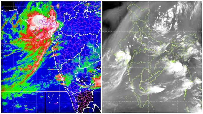
The Indian Space Research Organisation (ISRO) has released fresh satellite imagery capturing a large weather system over the Arabian Sea, providing a detailed view of the atmospheric conditions driving the current active phase of the southwest monsoon. The latest images show extensive cloud formations and moisture movement toward the Indian mainland, helping meteorologists closely monitor rainfall patterns across several states.
The satellite observations are being used alongside forecasts from the India Meteorological Department (IMD) to improve weather prediction accuracy and support disaster preparedness efforts.
Satellite Images Reveal Active Monsoon System
According to ISRO, the latest satellite imagery highlights a well-developed cloud mass over the Arabian Sea associated with the ongoing monsoon circulation.
The observations indicate:
- Dense cloud formations over the Arabian Sea.
- Strong moisture transport toward western and central India.
- Active monsoon circulation.
- Widespread rain-bearing cloud bands.
- Continuous weather system development over surrounding regions.
Scientists said such satellite observations play a vital role in monitoring rapidly changing weather conditions.
Supporting Weather Forecasting
The new imagery will assist meteorologists in tracking:
- Heavy rainfall zones.
- Movement of rain-bearing systems.
- Potential thunderstorm activity.
- Cyclonic circulation, if any develops.
- Flood-prone regions.
Weather agencies combine satellite data with radar observations and ground-based monitoring stations to produce more accurate forecasts.
Importance for Disaster Management
Officials said satellite monitoring helps disaster management agencies prepare for weather-related emergencies.
The data supports:
- Flood forecasting.
- Landslide risk assessment.
- River basin monitoring.
- Early warning systems.
- Emergency response planning.
Authorities can use the information to issue timely public advisories and coordinate relief measures when necessary.
Role of ISRO Satellites
India’s meteorological satellites continuously observe atmospheric conditions over the Indian Ocean and surrounding regions.
These satellites provide:
- High-resolution cloud imagery.
- Rainfall monitoring.
- Water vapour analysis.
- Storm tracking.
- Weather system evolution.
The information is shared with multiple government agencies responsible for weather forecasting and disaster response.
Monsoon Remains Active
The latest satellite observations coincide with continued IMD forecasts of widespread rainfall across many parts of the country.
Several states remain under heavy rainfall alerts, with authorities advising residents to remain cautious in flood-prone and landslide-prone regions.
Officials continue to monitor the evolving weather situation closely.
Looking Ahead
ISRO is expected to continue releasing updated satellite observations as the active monsoon progresses across India.
Meteorologists will use the latest imagery to refine rainfall forecasts and strengthen early warning systems, helping authorities respond more effectively to changing weather conditions during the remainder of the monsoon season.
Source: Indian Space Research Organisation (ISRO), India Meteorological Department (IMD), and official government weather updates.
Original Report: ISRO released fresh satellite imagery showing a large Arabian Sea weather system contributing to the active southwest monsoon across India.
Supreme News Network



เช็กลิสต์ชื่อวัด ศาลา และเวลาจัดส่งมีประโยชน์มากครับ
My webpage; oliviath.com (Marianne)