

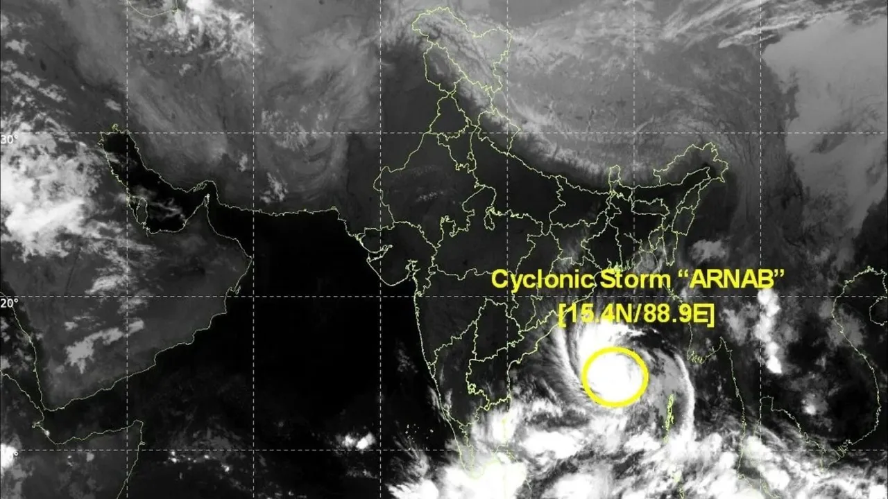
New Delhi/Bhubaneswar/Amaravati, October 26, 2026: Cyclonic Storm “Arnab” has formed over the east-central and adjoining west-central Bay of Bengal after a deep depression intensified early Monday, prompting authorities in Andhra Pradesh and Odisha to step up emergency preparations ahead of a potentially dangerous landfall later this week.
The India Meteorological Department expects Arnab to intensify into a severe cyclonic storm by October 27 and strengthen further before reaching the Andhra Pradesh coast on October 28.
IMD Confirms Cyclone Arnab Has Formed
The India Meteorological Department confirmed on Monday that the deep depression over the Bay of Bengal had intensified into Cyclonic Storm Arnab.
The storm is located over the east-central and adjoining west-central Bay of Bengal and is continuing to move toward India’s eastern coast.
Storm Moving Towards Andhra Pradesh Coast
The system has been moving west-northwestwards over the Bay of Bengal.
IMD forecasts indicate that the cyclone will gradually turn northwestwards as it approaches coastal Andhra Pradesh.
The projected track currently places the Andhra Pradesh coast directly in the path of the storm.
Landfall Expected Between Bapatla and Visakhapatnam
IMD currently expects Arnab to cross the Andhra Pradesh and Yanam coast between Bapatla and Visakhapatnam.
Landfall is forecast by the forenoon of October 28.
Meteorologists continue to monitor the system closely because cyclone tracks and intensity can change as atmospheric conditions evolve.
Very Severe Cyclonic Storm Possible
Arnab is forecast to become a severe cyclonic storm by the morning of October 27.
It may then intensify further into a very severe cyclonic storm before landfall.
IMD has projected maximum sustained wind speeds of 115–125 kmph, gusting to around 140 kmph, when the system reaches the coast.
Coastal Andhra Pradesh Faces Extremely Heavy Rain
IMD has issued significant rainfall warnings for coastal Andhra Pradesh.
For October 27 and October 28, parts of the region are under alerts for extremely heavy rainfall, along with strong surface winds.
Heavy rain could lead to flooding, waterlogging, crop damage and disruption to road and rail movement.
Strong Winds Expected Along Coast
As Arnab approaches land, wind speeds are expected to increase sharply along the Andhra Pradesh coast.
Very strong winds could damage trees, power lines, temporary structures and weaker buildings in vulnerable areas.
Authorities are therefore advising residents to secure loose objects and avoid unnecessary travel during the peak period.
Odisha Also Prepares for Cyclone Impact
Although the projected landfall point lies in Andhra Pradesh, neighbouring Odisha is also expected to experience significant weather effects.
Southern Odisha could receive heavy to extremely heavy rainfall, particularly in districts closer to the Andhra Pradesh border.
Five Odisha Districts Under Red Warning
Authorities have issued a red warning for several southern Odisha districts, including:
Ganjam, Gajapati, Koraput, Rayagada and Malkangiri.
These areas could experience heavy to very heavy rainfall, with isolated extremely heavy spells.
Odisha Begins Evacuation Preparations
The Odisha government has directed district administrations to identify vulnerable coastal and low-lying areas.
Officials have been asked to move people to cyclone shelters wherever necessary and prioritise evacuation before weather conditions deteriorate.
Zero-Casualty Approach Adopted
Odisha Chief Minister Mohan Charan Majhi has instructed officials to follow a zero-casualty approach.
District collectors and emergency officials have been told to remain at their headquarters and ensure rapid response if evacuations or rescue operations become necessary.
Disaster Response Forces Mobilised
Odisha has mobilised disaster-response personnel in preparation for the storm.
Around 60 Odisha Disaster Rapid Action Force teams, 17 National Disaster Response Force teams and 225 Fire Services teams have been placed on alert or deployed to vulnerable locations.
Ports Raise Warning Signals
Ports along the Andhra Pradesh and Odisha coasts have been instructed to display cautionary signals.
Visakhapatnam, Kakinada, Gangavaram, Machilipatnam, Nizampatnam and Krishnapatnam are among the ports where warning signals have been issued.
Odisha ports have also been advised to maintain Distant Cautionary Signal No. 1.
Sea Conditions Turning Dangerous
Sea conditions over the central Bay of Bengal are expected to become increasingly rough to very rough as the cyclone strengthens.
The combination of high winds, large waves and heavy rain will make maritime activity dangerous over the next several days.
Fishermen Told Not to Venture Into Sea
Authorities have advised fishermen not to venture into the affected parts of the Bay of Bengal.
Those already at sea have been asked to return to shore as soon as possible.
The advisory is particularly important for fishing communities along coastal Andhra Pradesh, Odisha and neighbouring regions.
Schools and Colleges Shut in Parts of Odisha
As a precautionary step, schools, colleges and Anganwadi centres in several vulnerable districts of Odisha have been ordered closed.
The closures are aimed at reducing public movement and ensuring children remain away from flood-prone or high-risk areas.
Emergency Medical Services Put on Alert
Andhra Pradesh authorities have also asked hospitals and emergency medical services to prepare for possible disruptions.
Medical teams are being readied in vulnerable coastal districts, while officials are monitoring power supply and road connectivity.
Heavy Rain Could Continue After Landfall
Even after Arnab crosses the coast, significant rainfall is expected to continue.
Coastal Andhra Pradesh remains under heavy-rain warnings through October 29, while parts of Odisha may experience intense rain and thunderstorms for several days.
Flooding and Crop Damage Are Key Concerns
Authorities are closely watching low-lying coastal areas, rivers, drainage systems and agricultural zones.
Extremely heavy rain combined with strong winds could damage standing crops, disrupt electricity supplies and cause localised flooding.
Residents Asked to Follow Official Bulletins
Officials have urged residents to rely on updates from IMD and state disaster-management agencies rather than unofficial cyclone forecasts circulating on social media.
People living in vulnerable areas have been advised to keep essential medicines, drinking water, food, torches and charged mobile phones ready.
October 27–28 Will Be Critical
The most dangerous period is currently expected between October 27 and October 28, when Arnab is forecast to intensify rapidly and approach the coast.
Weather conditions could deteriorate significantly during this period across coastal Andhra Pradesh and southern Odisha.
Cyclone Track Still Being Monitored
Although current forecasts place landfall between Bapatla and Visakhapatnam, cyclone paths can shift.
IMD is expected to issue frequent updates on the storm’s position, intensity and expected impact as Arnab moves closer to the coast.
Authorities Brace for Major Weather Event
Cyclone Arnab is now one of the most significant weather threats facing India’s east coast this season.
With the possibility of very severe cyclonic storm conditions, extremely heavy rain and winds approaching 140 kmph, Andhra Pradesh and Odisha are preparing for evacuations, infrastructure disruption and emergency response over the next 48 hours.
Source: India Meteorological Department, The Indian Express, The New Indian Express
Supreme News Network